Ten random state outlines
Guess 10 randomly chosen state shapes in a short round, with no repeats.
Play Quick 10Can you recognize a US state from its outline alone? Put your geography skills to the test with this free state shape quiz. Each question shows one state silhouette and four possible answers. Play a quick 10-question round or challenge yourself to identify all 50 states, including Alaska and Hawaii.
Play state shape quizLook at a state outline and pick its name from four options. Play a short round or challenge yourself to identify all 50 shapes.
Free to play · No sign-up · No timer
All the shapes point north, just as they do on a map. Smaller states are enlarged so you can see their outlines clearly.
Guess 10 randomly chosen state shapes in a short round, with no repeats.
Play Quick 10Try all 50 state shapes without repeats. If your browser allows progress to be saved, you can return later and pick up where you left off.
Try All 50Look at the outline, choose the state, and learn what makes its shape recognizable.
Look for a narrow panhandle, a peninsula, an unusual coastline, islands, or distinctive corners. The state name stays hidden.
Select one of four possible answers. There is no countdown, and you get one choice per question.
See the correct state and a visual recognition tip. At the end, review the shapes you missed before trying again.
Start with these eight distinctive outlines. Focus on what their outer borders look like, not how large the pictures are.
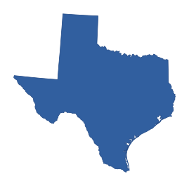
A large outline with a northern Panhandle, a broad middle section, a long Gulf Coast, and a sweeping curved southern Rio Grande border.
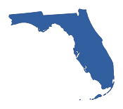
An unmistakable long peninsula pointing south, connected to a horizontal Panhandle extending west. The coast is deeply indented at the southern tip.
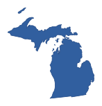
Two major disconnected peninsulas define the outline: a long Upper Peninsula and a mitten-like Lower Peninsula surrounded by lakes.

A distinctive narrow western Panhandle projects left from a much broader eastern body, whose southern boundary bends around Texas.

A boot-like outline with an irregular, deeply indented Gulf Coast and a narrow lower projection toward the Mississippi River delta.

A distinctive narrow northern panhandle sits above a wider, fairly rectangular southern section. The western side has an irregular step.
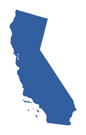
Long and narrow from north to south, with a curving Pacific coastline and a diagonal southeastern border. Its southern tip reaches the Mexican border.

Exceptionally long from west to east and relatively narrow north to south. Its northern edge is smoother than much of its southern boundary.
Before looking at the answers, notice the outline's corners, coastline, and narrow extensions. These four tips can help you recognize states without seeing them on a map.

Florida has a long southern peninsula and a westward Panhandle. Michigan has two separate peninsulas. Hawaii is a chain of islands rather than one continuous outline.
Try this: First count the separate land pieces, then look for a narrow projection or curved coast.

Oklahoma's narrow strip reaches west. Idaho's panhandle reaches north. West Virginia has a thin northern projection and an eastern arm.
Try this: Find which direction the narrow section points before comparing the main body.



Colorado and Wyoming are both close to rectangles, so they are genuinely hard to separate by shape alone. New Mexico has a small southwestern bootheel that breaks its box-like outline.
Try this: Do not guess from picture size; examine a small notch or projection instead.



Mississippi has a winding western river boundary. Missouri has a southeastern Bootheel. Kentucky has a long, uneven northern boundary along the Ohio River.
Try this: Trace the edge slowly and identify where a smooth line becomes wavy or suddenly extends.
First count any separate islands or peninsulas. Then look for narrow extensions, straight borders, and curved coastlines or rivers. Some states, especially Colorado and Wyoming, are still hard to tell apart by shape alone.
Some outlines really are difficult to tell apart. Compare their edges and projections side by side.
Both are nearly rectangular. Neither has a dramatic coastline or peninsula, so focus on subtle edge differences; a single small silhouette can be genuinely difficult.


Both are broad plains states. North Dakota's northern border is especially straight; South Dakota shows more bends along part of its southeastern river boundary.


Kansas is close to a clean rectangle. Nebraska has a more irregular eastern river edge and a small southeastern extension.


Vermont narrows toward the south, while New Hampshire generally widens in its lower half and has a short ocean-facing edge.

Both are tall southern outlines. Mississippi's western boundary is markedly wavy along the river; Alabama's western border is straighter.


North Carolina is long and narrow from west to east; South Carolina is more compact and wedge-like, broadening toward its coast.

Both have broad, mostly straight-edged southwestern outlines. Arizona's western border slopes along the Colorado River, while New Mexico looks squarer and has a small southwestern bootheel.
Both stretch from west to east. Tennessee is long and comparatively narrow, while Kentucky becomes pointed at its eastern end and has a more winding northern river border.
Open a region to explore each state's silhouette, two-letter abbreviation, and a feature to remember. This collection includes 50 states but excludes Washington, D.C. and US territories.

Compact and broad from east to west, with a mostly straight northern edge and an irregular southern coastline along Long Island Sound.

An irregular outline with a rugged eastern coastline and an angled northern border, broader in the north than at the southern coastal tip.

A long east–west shape with the curved Cape Cod peninsula hooking outward at the eastern coast.
A narrow north–south shape that widens toward the south, with an irregular western river boundary and a tiny southeastern coastline.

A slender north–south shape with a curved Atlantic coast, a tapered southern end, and a slightly bulging northern section.

A broad horizontal mainland shape with a long southeastern projection toward New York City and a complex coastline including Long Island.

A wide, mostly rectangular outline with an irregular northwestern Lake Erie corner and a small, curved eastern boundary.

A very compact, irregular coastal outline with bays and islands. The silhouette is much less rectangular than neighboring Connecticut.
Narrow and tall, widening toward the northern end and tapering to a point in the south. It lacks an ocean coastline.

A tall north–south shape with a wavy Mississippi River edge to the west and a small notch of Lake Michigan at the northeast corner.

A compact upright shape with a short Lake Michigan shoreline at the northwest corner. Most edges are quite straight except the southern river border.

A broad, fairly regular shape whose eastern and western edges follow rivers, creating a gently wavy silhouette.
A long, mostly rectangular shape with a fairly straight top and bottom. Its northeastern and eastern edges have subtle river-related variations.
Two major disconnected peninsulas define the outline: a long Upper Peninsula and a mitten-like Lower Peninsula surrounded by lakes.

A tall northern outline with a small northward projection and a notched northeastern edge along Lake Superior.
A broad shape with a distinctive southeastern Bootheel projecting downward beneath the otherwise straighter southern border.
A broad, roughly rectangular Great Plains shape with a noticeably irregular eastern edge and a slight southeastern extension.
A broad northern shape with a very straight top, west, and much of the south; its eastern border follows a gently curving river.

A compact, roughly upright shape with an irregular Lake Erie shoreline on top and a wavy Ohio River border to the south.
A broad, box-like northern plains silhouette with mainly straight outer borders and some river-shaped irregularities on the southeast.

A fairly upright silhouette with Lake Michigan forming much of the eastern edge and a northward peninsula-like outline near Lake Superior.
A tall, fairly straight-sided outline with a short, uneven Gulf Coast edge. The top is comparatively flat, while the southeast corner meets the Florida Panhandle.

A roughly rectangular outline interrupted by a wavy eastern river boundary. The northern and western edges are comparatively straight.

Very narrow and upright, with a curved eastern shoreline facing Delaware Bay and a relatively straight western side.
An unmistakable long peninsula pointing south, connected to a horizontal Panhandle extending west. The coast is deeply indented at the southern tip.

A broad shape that narrows toward the southeast, with an uneven Atlantic coastline and a slanting western boundary against Alabama.
An elongated east–west shape that tapers toward the eastern mountains. The northern boundary is a noticeably irregular river line.
A boot-like outline with an irregular, deeply indented Gulf Coast and a narrow lower projection toward the Mississippi River delta.

An especially irregular shape with a narrow western arm stretching left and Chesapeake Bay cutting into the eastern side.
A tall upright shape with a wavy western river border and only a short southern coastline. The northern edge is quite straight.
A long east–west shape that narrows toward its western mountains, with a jagged eastern shore and the projecting Outer Banks.
A distinctive narrow western Panhandle projects left from a much broader eastern body, whose southern boundary bends around Texas.
A rough triangular or wedge-shaped outline, tapering toward the northwest and opening out along its curved Atlantic coast.
Exceptionally long from west to east and relatively narrow north to south. Its northern edge is smoother than much of its southern boundary.
A large outline with a northern Panhandle, a broad middle section, a long Gulf Coast, and a sweeping curved southern Rio Grande border.

A long, uneven east–west outline, with a projecting eastern peninsula and an irregular western mountain edge.
An irregular Appalachian outline with a distinctive thin northern panhandle reaching toward Pennsylvania and an eastern panhandle extending right.
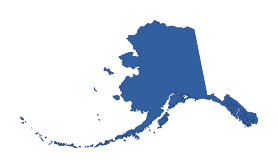
An expansive, jagged mainland with a long chain of islands stretching southwest. The coastline has many deep inlets and a prominent western peninsula.
A mostly straight-edged southwestern shape with a slanting western border and a less regular southern edge. The northeastern corner meets the Four Corners.
Long and narrow from north to south, with a curving Pacific coastline and a diagonal southeastern border. Its southern tip reaches the Mexican border.
An almost rectangular outline with mostly straight borders and a few slight bends. It can easily be mistaken for Wyoming at a glance.
A chain of separate island shapes rather than one continuous landmass. The islands form a diagonal line across the Pacific.
A distinctive narrow northern panhandle sits above a wider, fairly rectangular southern section. The western side has an irregular step.

A wide northern shape with a long straight Canadian border and a much more uneven western edge along the Rocky Mountains.

A tall, slanted shape whose long western edge runs diagonally. The southern tip comes to a point beside California and Arizona.
A nearly square outline with a small projecting southwestern bootheel. Its east and north sides are mostly straight.
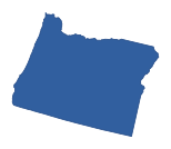
A broad western shape with a nearly straight northern edge and a jagged Pacific coastline, narrowing somewhat toward the east.

A tall, nearly rectangular western silhouette with a step-like northeastern corner and an unusually straight western side.
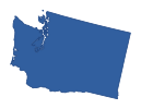
A broad northwestern outline with a straight Canadian border on top and a complex Pacific coast with inlets in the northwest.
A very regular, almost rectangular outline with four mostly straight sides. It resembles Colorado but differs in subtle border details.
All outlines face north, but each is enlarged or reduced to make its shape clear. A bigger picture does not mean a bigger state.
A few common questions before your next round.
Yes. Choose All 50 to identify every US state outline once, including Alaska and Hawaii. Quick 10 uses ten different random state shapes.
Yes. Both game modes are free, and you can play without signing up, installing an app, or starting a timer.
Yes. Alaska is shown with its major coastal outline and islands, while Hawaii appears as a chain of islands. Both are included in the full challenge.
Each state shape is resized to fit the picture without stretching it. This makes smaller states easier to see, but the pictures do not show how large the states are compared with each other.
Colorado and Wyoming are both nearly rectangular; Kansas and Nebraska, North and South Dakota, and Vermont and New Hampshire can also be tricky. Compare distinctive edges rather than the size of the image.
Here you see an unlabeled silhouette and choose a state name. In the US States Map Quiz, you see a state name and click its location on a full map. They practice different geography skills.
Know the shapes? Try finding those states in our US States Map Quiz, recognize national flags in the Flag Quiz, or play the quick geography quiz.
These outlines are based on US Atlas, which uses US Census Bureau cartographic boundary data (2017). The outlines may simplify very small coastal details and islands; Michigan's two peninsulas and Hawaii's islands remain part of their shapes.
To make the states easier to browse, we have organized them using the US Census Bureau's regions. Map license information. Last reviewed: .